China
Beijing
|
|
Chinese Opera
|
|
|
Great Wall
|
|
|
Temple of Heaven
|
Luoyang
|
Longmen Grottoes
|
|
Shanghai
|
|
Acrobat Show
|
|
The Bund
|
|
|
|
Yuyuan gardens
|
Shaolin
|
Calligraphy
|
|
|
|
Kung Fu
|
|
Pagoda Forest
|
|
|
|
Shaolin Temple
The Shaolin Temple was built in 495 AD by Emperor Xiaowen of the Northern Wei Dynasty for the Indian monk Batuo. Thirty-two years later, another Indian monk Bodhidharma arrived at Shaolin Temple. He was the first monk to preach Chan doctrines here, and thus was honored as the first Patriarch of Chinese Chan. Thereafter, Shaolin Temple was recognized as the origin of Chan Buddhism. In addition, martial arts have been practiced at the temple throughout its history. The unique combination of Shaolin Kung Fu and Chan Buddhism is the essence of Shaolin culture. Situated at the central peak of Song Mountain, the temple was frequented by the generals and emperors of China. Until its modern renaissance, the golden age of the monastery is said to have been during the Tang Dynasty (618-907 AD). At the beginning of the seventh century, a tiny army of 13 Shaolin monks was reputed to have saved future Tang Dynasty emperor Li Shimin. When he assumed the throne, Li showered favors, land and wealth on the temple. It thrived as the center of kung fu, with masters from all around the country. Shaolin Temple peaked in the Ming Dynasty (1368-1644) and began to decline in the Qing Dynasty (1644-1911). At its heyday, it housed more than 3,000 monks. |
Xi'an
Benefiting from the fertile land and comfortable climate in ancient time, the rulers of 13 dynasties have set up their capitals in Xian successively. Thus, Xian is one of the cities which preserve a wealth of historical heritages in China. The Lantian Man, which was found in Lantian County of Xian, has inhabited in this land about 800,000 years ago. Coming to 300,000-400,000 years ago, the primitive people around Xian have turned into the stage of primitive clan communes gradually. The base of this region's agricultural production should be started when the Banpo Man made living here about 6,000 years ago. They have settled down in the eastern suburban of Xian City, setting up the Matriarchal clan villages.
The slave society of China mainly refers to the periods of the Xia (21st-16th century BC), Shang (16th-11th century BC), Western Zhou (11th century BC-771BC) as well as Spring and Autumn Peroid (770 BC-476). During this long history, more and more nations have immigrated to the Guanzhong Plain the center of which is just current Xian. Therefore, both of this region's economy and political system has gained rapid development. Until to the Western Zhou Dynasty, the Wenwang have moved the capital-Fengjing to the west bank of the Fenghe River nearby Xian. It played as the dynasty's religious and cultural center. Later, his heir Wuwang built the political center on the east bank of the Fenghe River, namely, Haojing. This should be the first recorded dynasty founded the capital in Xian City.
Coming to the end of the Eastern Zhou Dynasty, namely, the Warring States Period, there mainly distributed seven powerful states in China. Qin, one of the seven states, was located in the center of Shaanxi Province and east Gansu Province. Later, Ying Zheng, Emperor Qin Shi Huang, set up the first feudal dynasty in Xianyang (consists of current Xian and Xianyang cites) after unifying the other six states.
The Western Han Dynasty (206 BC-24AD), which is the third dynasty setting up its capital in Xian, constructed its capital -Chang'an on the relics of the Qin's Xianyang. Once, Chang'an City was the largest one in the world, covering an area of about 36 square kilometers (13.9 square miles). Now, the site of the Weiyang Palace is preserved well in Xian. The famous 'Silk Road' which starts from the Chang'an City appeared during the period of Wudi, opening the communication between China and overseas countries. On the other hand, the emperors carried out a series of policies to help the rehabilitation of the people. The Chang'an became a thriving city both in economy and polity in the world wide.
At the found of the Sui Dynasty, the Han's Chang'an City has been destroyed seriously owing to long years of wars from 220 to 589. Therefore, the emperor built a new city just to southeast of the old Chang'an City, called Daxing City. After the Tang Dynasty overthrew the Sui and captured the Daxing City, the first emperor of Tang renamed the city as Chang'an City again. Later, some subsequent construct and renovation projects were taken. There is no doubt that Tang should be the most prosperous dynasty in Chinese history. Thus, as the center, Chang'an was one of the largest economical, political and cultural centers in the world at that time.
From the end of the Tang Dynasty, the Chang'an City has lost its top position gradually; however, it was still one of the vital prefectures in the later dynasties. In 1369 of the Ming Dynasty, Xian gained its current name officially. From the next year, the current Xian City Wall has been constructed.
|
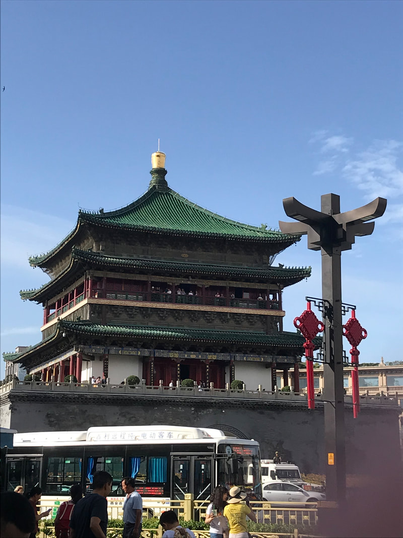
Belltower
Xi'an Bell Tower was built in the 17th year of Hongwu in the Ming Dynasty (1384). It was originally located at the Yingxiang Temple of Guangji Street, north of West Street, facing the Xi’an Drum Tower, about one kilometer away from its current location. At that time, this place was directly opposite the north and south city gates, and it was the center of the city. With the expansion of Chang'an City in the early Ming Dynasty, the city center gradually moved eastward. After two centuries, the city gate was rebuilt, and the new four streets of East, South, West, and North were formed. The bell tower at Yingxiang Temple seemed to deviate from the center of the city. In 1582, under the auspices of Shaanxi Provincial Supervision Officer Gong Yuxian, the county magistrates of Xianning and Chang'an were ordered to relocate them to the present site. In addition to rebuilding the pedestal, the construction of the intrinsic structure is all original, so the cost is not much and the project is rapid. In 1699, 1740 and 1840, Xi'an Bell Tower was repaired on a large scale. On October 10, 1939, the Xi'an Bell Tower was bombed by Japanese planes and was seriously damaged. After the bell tower was bombed, the Xijing Municipal Construction Committee Engineering Office repaired it. After the founding of the People's Republic of China, Xi'an Bell Tower was overhauled five times. In August 1956, it was listed in the Shaanxi Provincial People's Government as the first batch of key cultural relics protection units in Shaanxi Province. It was officially opened to the public in 1984. In November 1996, it was included in the national key cultural relics protection unit. |
|
|
|
Daming Palace
The Tang Dynasty grew rich from Silk Road trade and its control over a vast empire. Li Shimin who was the second emperor of the Tang Empire built a palace for his father to live in in the year 634. Li Shimin deposed his father in the year 626. His father was the first emperor of the dynasty. He built the palace area outside the main city to give his father an out of the way place to retire in, but before the palace was completed, his father died in the year 635. In 662, another emperor named Gaozong added a lot of gardens and constructed a lot of buildings, and the Daming Palace area became his clan's dwelling quarters. He fortified the area extensively. The area was destroyed in war in the year 896. At one time, the Daming Palace area had several palaces and temples. The biggest palace was called Huayuan. Other palaces were used to meet officials or foreign ambassadors. There were gates leading both into the main city and out to other sides. There was also a big pond called Taiye pond and a garden that people enjoyed. There was an archery hall, a bathhouse, storehouses, a drum tower, a bell tower, a Cuju (the ancient football) sports filed, and a separate entertainment ward. |
|
Terracotta Warriors
The construction of the tomb was described by historian Sima Qian (145–90 BCE) in Records of the Grand Historian, the first of China's 24 dynastic histories, which was written a century after the mausoleum's completion. Work on the mausoleum began in 246 BCE soon after Emperor Qin (then aged 13) ascended the throne, and the project eventually involved 700,000 conscripted workers. Sima Qian wrote that the first emperor was buried with palaces, towers, officials, valuable artifacts and wondrous objects. According to this account, 100 flowing rivers were simulated using mercury, and above them the ceiling was decorated with heavenly bodies, below which were the features of the land. High levels of mercury were found in the soil of the tomb mound, giving credence to Sima Qian's account. The Terracotta Army was discovered on 29 March 1974 by a group of farmers—Yang Zhifa, his five brothers, and neighbour Wang Puzhi—who were digging a well approximately 1.5 kilometres (0.93 mi) east of the Qin Emperor's tomb mound at Mount Li (Lishan), a region riddled with underground springs and watercourses. A museum complex has since been constructed over the area, the largest pit being enclosed by a roofed structure. |
|
Xiahe
Xiahe is a county in Gannan Tibetan Autonomous Prefecture, Gansu province, the People’s Republic of China, bordering Qinghai province to the west. It is home to the famed Labrang Tibetan Buddhist monaster, one of the largest Tibetan Buddhist monasteries outside the Tibet Autonomous Region. The town is populated largely by ethnic Tibetans, as well as some Hui and Han Chinese. The area is highly rural and pastoral (including yak and other animal rearing). The geography is mountainous. The county was named Xiahe in 1928, after the Daxia River that flows through its territory. Xiahe (Sangqu) used to be part of Qinghai when it was under the control of Chinese Muslim General Ma Qi. It was the site of bloody battles between Muslim and Tibetan forces.
|
|
Labrang Monastery
Labrang Monastery was formally founded in 1709, on the three hundredth anniversary of the founding of Ganden Monastery in central Tibet. Ground was broken for the Main Meeting Hall in 1710, and a tent was pitched for immediate use in a summer pasture in the Khagya tsodruk region. The land was donated by Tibetan nomads from Genkya, and sponsorship provided by Mongols from Tsekhok, led by the Khoshud Erdeni Jinong. The primary religious founder was the First Jamyang Zhepa. The importance of Labrang as a center for Tibetan Buddhism and for Tibetan culture should not be underestimated. The Jamyang Zhepa's central Tibetan Gelukpa political and academic background served as a model for many of Labrang's key figures. Many if not most of the prominent Labrang scholars and leaders were Amdo natives, educated at Gomang, and established in the greater Labrang community. Labrang's ongoing political relationship with central Tibet is marked by the First Jamyang Zhepa's high profile in Tibetan, Mongol, and Qing Dynasty affairs in central Tibet in the late seventeenth and early eighteenth century. His successors maintained close ties to the Tibetan government and the authorities in the major central Tibetan monasteries. |
|
Sangke Grassland
Lying at an average altitude of over 3,000m above sea level, Sangke Grassland is situated a short 14km from Xiahe. This vast expanse of grassy plains, covers an area of around 70 square kilometers. There are only 4,000 Tibetan nomads on the grasslands who graze yak herds and offer tourists the chance of a ride upon their horses. Located 1 km southwest of Xiahe County, Sangke Grassland belongs to the Dajiu flatland (Horse-racing flatland) in the Sangke Township. Embraced by mountain of each side, it is fertile alpine grassland famous for its verdant grass and beautiful scenery with blue sky, fluffy clouds, vast lush grassland dotted with herds of sleep and cattle |
|
