Chinchero
There are vestiges that date back approximately two thousand years. The first inhabitants of the region were the Ayarmacas who, when the first Cusco governors arrived, defended their territory and offered serious resistance before being incorporated into the empire. Chinchero was the place chosen by the Inca Tupac Inca Yupanqui to establish his residence. He had beautiful palaces built for his personal use and that of his panaca.
Towards 1536, in the middle of the invasion, Manco Inca began his rebellion by burning Chinchero in Cusco - Perú so that the Spanish did not renew their provisions and stopped pursuing him in his retreat to unknown jungle regions. When Viceroy Toledo visited Cusco, he stopped at Chinchero. Here he established a reduction of Indians and ordered the construction of the current church, which was built on beautiful Inca rooms. Later, during the Tupac Amaru II revolution, the curaca of Chinchero, Mateo García Pamacahua, rose in favor of the King of Spain to fight the rebel. Pumacahua's triumph was eternalized in a mural that today features a cougar defeating a snake (amaru).
Towards 1536, in the middle of the invasion, Manco Inca began his rebellion by burning Chinchero in Cusco - Perú so that the Spanish did not renew their provisions and stopped pursuing him in his retreat to unknown jungle regions. When Viceroy Toledo visited Cusco, he stopped at Chinchero. Here he established a reduction of Indians and ordered the construction of the current church, which was built on beautiful Inca rooms. Later, during the Tupac Amaru II revolution, the curaca of Chinchero, Mateo García Pamacahua, rose in favor of the King of Spain to fight the rebel. Pumacahua's triumph was eternalized in a mural that today features a cougar defeating a snake (amaru).
|
|
Textile Cooperative of Chinchero
The Centro de Textiles Tradicionales del Cusco (CTTC) is a non-profit organization that was established in 1996 by Andean weavers and their supporters. The mission of the Center is to aid in the survival of Cusqueñan textile traditions and to provide support to the indigenous people who create them. The Center works with ten weaving communities in the Cusco region of Peru on a fair-trade basis to help rescue traditions and promote the weavers and their work. Through community organization, workshops, educational opportunities and more the Centro de Textiles Tradicionales del Cusco ensures that there is a future for Cusqueñan textile traditions. |
Cusco
|
|
Convent of Santo Domingo
|
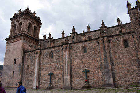
Cusco Cathedral
Qhelpa
|
|
Sacsayhuaman
|
|
|
San Blas Temple
|
|
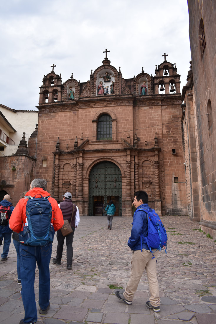
Templo de la Sagrada Familia
|
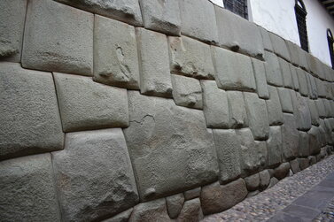
Twelve-angled Stone
Inca Trail
|
|
Chaksi stop ruins
|
|
|
Intipata
|
|
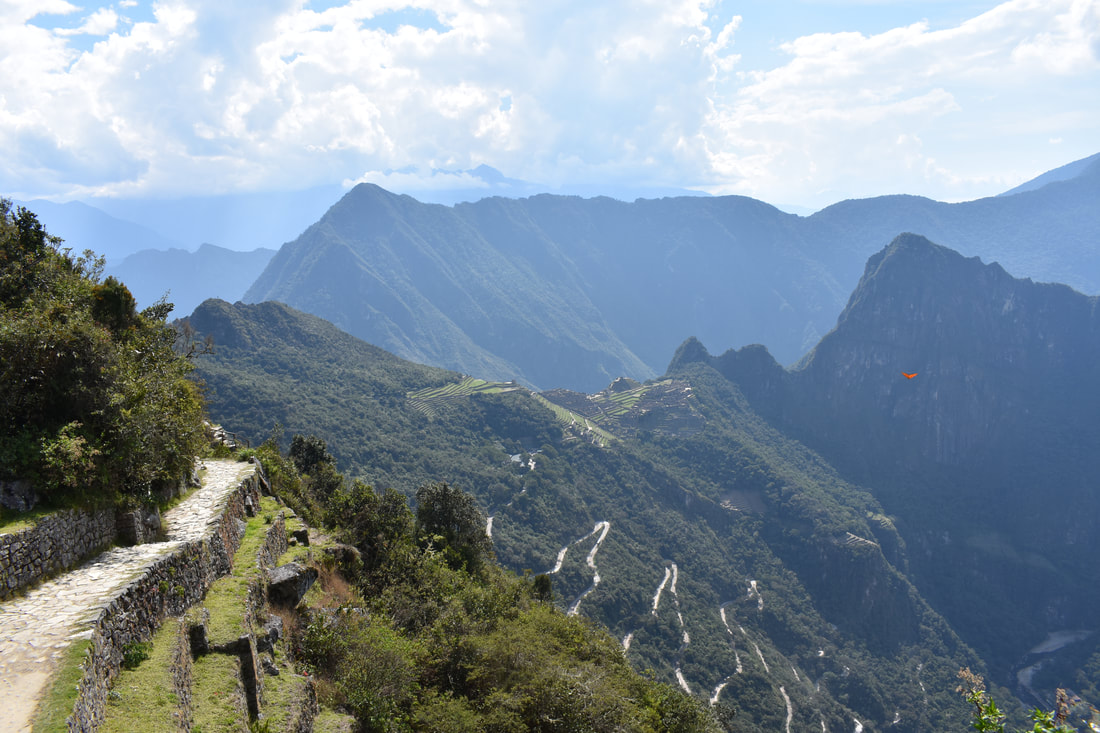
The Trail
|
|
|
|
Phuyupatamarca
Phuyupatamarca, the place of the clouds. Located at an altitude of 3670 meters above the sea level Phuyupatamarca, is a place that took your breath away because of the amazing view that you’re watching. Like many Inca sites, this is not the exception that combined balance between nature and the environment, a classical and traditional aspect of the Inca Philosophy and magical believes. The place is called of the clouds because most of the year is surround by big and thick clouds, due to its nearness to the Ceja de Selva (Low jungle). This site is formed by platforms and many ritual baths that functioned for sacred and religious ceremonies. |
|
Runkurakay Pass
A circular building located near the Inca Trail leading to Machu Picchu is only visited by those who choose to hike to the ruins of Machu Picchu. The ruin is located several kilometers/miles away from the closest road, therefore it is inaccessible to those who don't approach it through the Inca Trail. Runcuracay's location is near the pass with the same name, at an altitude of just under 4.000 m. This building must have been a post house or an Inca tambo. Most likely a tambo. A place where the chasquis messengers would stop over for food and rest for a while, until they could continue their trip onward. |
|
|
|
Sayaqmarka
The ruin was originally build by the Colla, the biggest enemy of the Incas before they became kings of the Peruvian highlands. The Incas improved the site that had only one weakness: there is not room for agriculture. A small ruin next to Sayacmarca functioned as the farm of this small city where only 200 people could live. But again, this spot was perfect because of its strategy and inside people and religion can live in perfect harmony. The only frailty was food in case of a military occupation. So several big rooms of Sayacmarca must have been reserved as a warehouse. |
|
Winaywayna
The Winay Wayna ruins in Perú date back to the mid-15th century, built during the days of the mighty Inca Empire. They are one of the stops along the Inca Trail, and the exact purpose of the site is difficult to say. It may have been a spiritual or religious destination, or simply a place for elders or royalty to rest before reaching the end of the 26-mile journey to Machu Picchu. The Winay Wayna ruins in Perú consist of upper and lower collections of Inca architecture, connected by stone steps that appear in elegant curves. The upper structures have a unique circular building, while below is a collection of linear parapets with sharp peaks, jagged walls, and huge stone slabs with little space between them. The precarious staircase between the two levels embraces a long line of ancient fountains, often called baths. In addition to the architectural structures, the area is surrounded by an agricultural complex, terraced with extraordinary masonry of local stones. |
|
Machu Picchu
Historians believe Machu Picchu was built at the height of the Inca Empire, which dominated western South America in the 15th and 16th centuries. It was abandoned an estimated 100 years after its construction, probably around the time the Spanish began their conquest of the mighty pre-Columbian civilization in the 1530s. There is no evidence that the conquistadors ever attacked or even reached the mountaintop citadel, however; for this reason, some have suggested that the residents’ desertion occurred because of a smallpox epidemic.
Many modern-day archaeologists now believe that Machu Picchu served as a royal estate for Inca emperors and nobles. Others have theorized that it was a religious site, pointing to its proximity to mountains and other geographical features that the Incas held sacred. Dozens of alternate hypotheses have cropped up in the years since Machu Picchu was first unveiled to the world, with scholars variously interpreting it as a prison, a trade hub, a station for testing new crops, a women’s retreat or a city devoted to the coronation of kings, among many examples.
Many modern-day archaeologists now believe that Machu Picchu served as a royal estate for Inca emperors and nobles. Others have theorized that it was a religious site, pointing to its proximity to mountains and other geographical features that the Incas held sacred. Dozens of alternate hypotheses have cropped up in the years since Machu Picchu was first unveiled to the world, with scholars variously interpreting it as a prison, a trade hub, a station for testing new crops, a women’s retreat or a city devoted to the coronation of kings, among many examples.
|
|
Incan Bridge
The Inca Bridge of Machu Picchu is a wooden construction located on a narrow path next to a granite mountain and a ravine. The bridge is supported by a rustic stone construction on the edge of the abyss. Due to the difficult geography where it was built, it is believed that it served as the limit of Machupicchu with the west side. In case of invasion, the Incas could remove the bridge and prevent access to the citadel. |
|
Intihuatana, Hitching Post of the Sun
The Inca also paid close attention to the sky for divine inspiration. To the Inca, the sun was a divine being, called Inti, and from his coupling with his sister Quilla the moon, came the first Sapa Inca or supreme ruler of mankind. Inti’s yearly passage through the celestial sphere was of primary importance to the Inca. Using sophisticated geometric principles, they designed elaborate markers of stone to accurately calculate the dates of the solstices and equinoxes, essential points on the famous Inca calendar. These points regulated not only the spiritual life of the entire empire, but also the more humdrum but important yearly schedules for agriculture, herding, and rites of passage. One extraordinary structure at Machu Picchu used to trace Inti remains partially intact. The Inti Watana or “hitching post of the sun” is just one of many such posts, sadly destroyed en masse by the Spanish. These large pillars or gnomons are positioned to accurately pinpoint the key events of the astrological year. During the winter solstice (June 21), the gnomon casts a long shadow south. Conversely, during the summer solstice (December 21), the gnomon casts its shortest shadow to the northern side. On the autumnal and vernal equinoxes, at midday, the gnomon casts no shadow at all. Each year during the Summer Solstice, the High Priest of the Inca would climb up to the gnomon to ritually “hitch” the sun to the earth, thereby ensuring that Inti would not escape, but begin his journey anew. |
|
|
Intipunku, the Sun Gate
During the Inca apogee, the people who entered Machu Picchu after traveling the Inca Trail, had their first vision of the Inca city, from the Inti Punku; like the people who travel the Inca Trail today. The Sun Gate Machu Picchu or Inti Punku was a kind of control gate for people entering and leaving the Inca City. Because of its remote and strategic location, it is believed that Machu Picchu only welcomed guests and selected from the elite of the empire. It is known that people who returned after seeing the city, were treated with greater respect, by people who were on their way to the sacred city. The construction is dedicated to the sun, but not only in name, since during the summer solstice, the sun appears in the Inca City for this place. Definitely the views will cut your breath; Machu Picchu, the Urubamba river, the Huayna Picchu mountain and surroundings are observed. It is a large place, with windows and doors supported by terraces; from this place you can see the entire Inca City in the middle of the mountains. |
|
Machu Picchu Ruins
Tucked away in the rocky countryside northwest of Cuzco, Peru, Machu Picchu is believed to have been a royal estate or sacred religious site for Inca leaders, whose civilization was virtually wiped out by Spanish invaders in the 16th century. For hundreds of years, until the American archaeologist Hiram Bingham stumbled upon it in 1911, the abandoned citadel’s existence was a secret known only to peasants living in the region. The site stretches over an impressive 5-mile distance, featuring more than 3,000 stone steps that link its many different levels. Today, hundreds of thousands of people tramp through Machu Picchu every year, braving crowds and landslides to see the sun set over its towering stone monuments and marvel at the mysterious splendor of one of the world’s most famous manmade wonders. |
|
|
Main Temple
Situated on the Sacred Plaza in the Urban Sector of Machu Picchu, the Main Temple is an impressive rectangular shaped building consisting of 2 lateral walls and 1 rear wall. The base of the temple is made up of large lithic stones which support more regular sized and precisely carved stones. The Main Temple features a total of 17 trapezoidal shaped niches which were most likely used for ceremonial offerings. The rear wall of the temple also has 6 large stone pegs, which were probably used to hang decorations or aid in some way the rituals carried out at the temple. During Inca times it was said that the Temple was adorned with colourful mantles, emblems and mummies of the most important Inca leaders. The temple supposedly housed an effigy of P’unchao, a divine sacred symbol made of solid gold representing the Inca God Wiraqocha. When the Incas abandoned Machu Picchu at the time of the Spanish conquest, they took with them all the most important artefacts leaving behind just the stone structure which we see today. Various earthquakes over the years have undermined the structure of the Main Temple causing damage. |
|
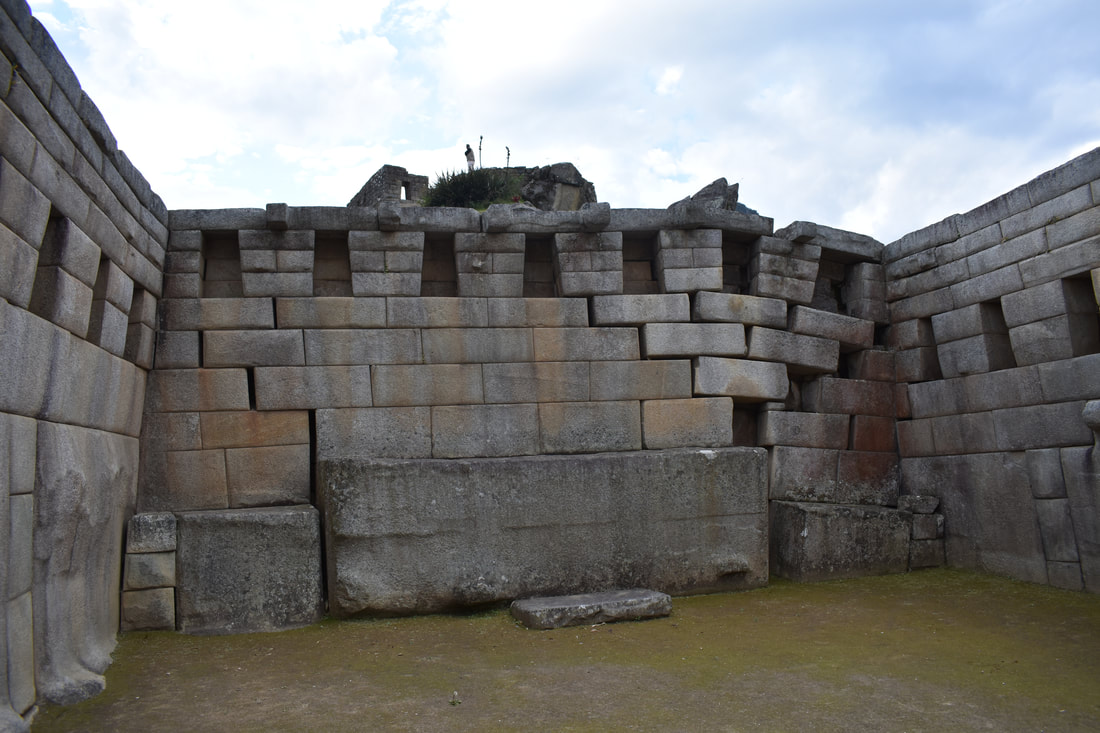
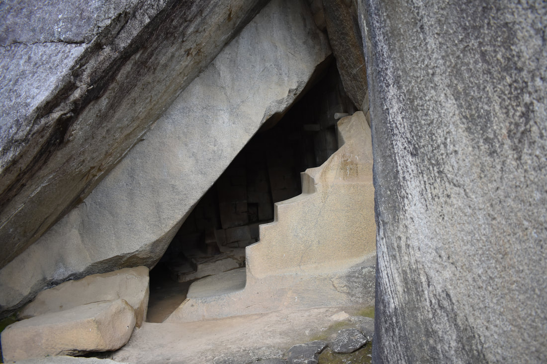
Mother Earth’s Temple or Royal Tomb
The Royal Tomb is located below the Temple of the Sun, and is one of the most important tombs in Machu Picchu. Formed by a small natural cave with an opening facing to the east, the interior of the Royal Tomb is made up of finely carved stones, niches and lithic pegs. The main feature of the tomb is a large alter with 2 levels and a symbolic stair case carved insitu in the natural rock. Due to the fine stone carvings and the location of the tomb within the Urban Sector of Machu Picchu, historians deduce that the Royal Tomb was used uniquely for hierarchical mummies that belonged to Machu Picchu. Although the term tomb suggests a closed dark burial chamber, the tomb was actually open to light, specifically in the mornings, when the sunrise illuminated the entire tomb. The tomb could have been considered more like a chapel, a place of worship, and less like the closed tombs that were found elsewhere within the citadel. |
|
|
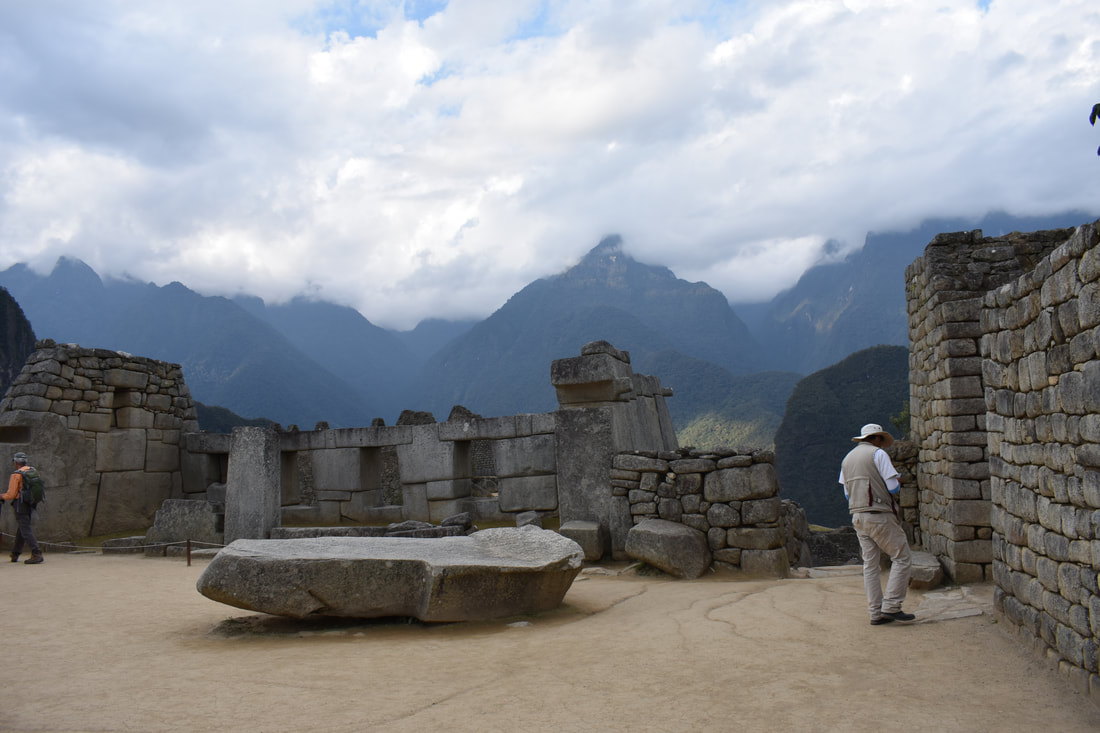
Sacred Square
The Sacred Plaza has been designated as the political center of the urban sector. It is surrounded, or better said, consisting of the main temple, the sacred Temple of the Three Windows and the Intihuatana (religious symbol represented by a carved Aerolite in solid rock), although also sits to the House of the priest and the sacred Temple of the Moon. It is all surrounded by terraces, they not were intended for cultivation, as it would be expected, but they were designed to accommodate the large number of attendees present in all the different celebrations and festivities of the city. The Citadel of Machu Picchu can get to be seen two large plazas that were aimed at the conclusion of these ceremonies and rituals, although it should be noted that the most important was undoubtedly the sacred Plaza or Plaza Principal of Machu Picchu. |
|
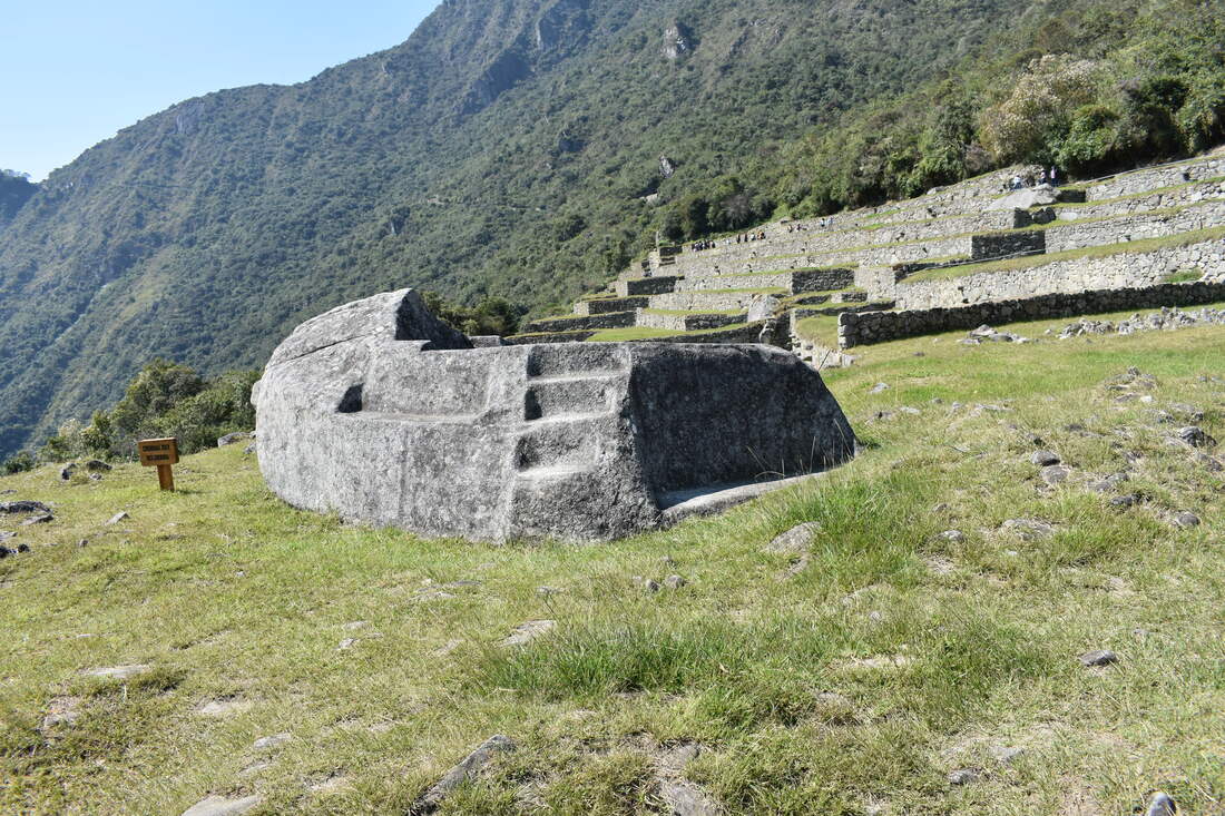
Sacrifice Rock
The rock funeral home, located in the agricultural sector of the city, took its name from the different scenarios of the expert community of anthropology after multiple discoveries of mass graves with human remains. The rock has a symbolic character that led to the entry of the necropolis of the Citadel of Machu Picchu. Its proximity to this cemetery gave the character of Idol, so the area where might have come to host large numbers of funeral ceremonies and religious offerings of the city. The funerary rock represents the chapel sanctuary of the city of Machu Picchu. Archaeological findings have been able to explain that the rock funeral home was designed to serve as a chapel which he presents common elements of this type of buildings. Because of its burial character, this building was designated to accommodate the process of mummification through the embalmed corpses drying procedure. However, other theories have tried to explain that the rock funeral home had a close relationship with the study of the stars and more particularly of the Sun, the light of this refusal in it during the Ibiza the year, phenomenon that could have been part of the religious beliefs of this civilization. |
|
|
|
Temple of the Condor
On the floor of the temple is a rock carved in the shape of the condor's head and neck feathers, completing the figure of a three-dimensional bird. Historians speculate that the head of the condor was used as a sacrificial altar. Under the temple is a small cave that contained a mummy. A prison complex stands directly behind the temple, and is comprised of human-sized niches and an underground maze of dungeons. According to historical chronicles that documented similar Inca prison sites, an accused citizen would be shackled into the niches for up to 3 days to await the deliberation of his fate. He could be put to death for such sins as laziness, lust, or theft. |
|
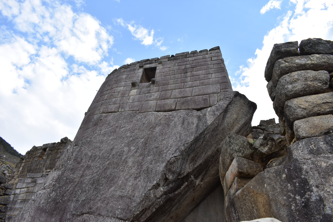
Temple of the Sun
Only priests and other high ranking Incas were likely only permitted access into the Temple of the Sun, one of the most sacred temples in all of Machu Picchu. Adapted to the natural environment, the unique semi-circular construction of the temple is built over an enormous granite rock and there’s a tower with a trapezoidal window. In this sacred temple, it’s believed that Incas worshipped their Sun God, Inti and may have served as a royal tomb. |
|
|
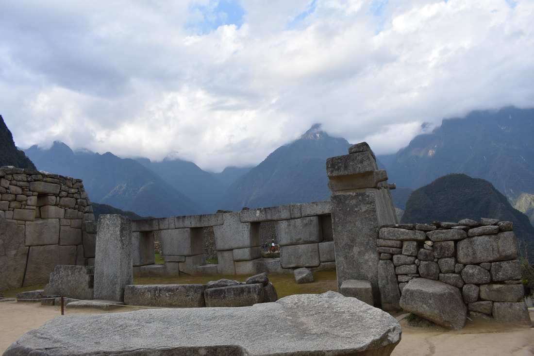
Temple of the Three Windows
Just 3 of the 5 windows are remaining, and these 3 windows represent each part of the world: The underground (Uku-Pacha) the heaven (Hanan-Pacha) and the present or the actual time (Kay-Pacha). These windows also represent the rise of the sun, an important event in the everyday life of the Inca population. |
Maras
Maras is a town in the Sacred Valley of the Incas, 40 kilometers north of Cusco, in the Cusco Region of Peru. The town is well known for its salt evaporation ponds, located towards Urubamba from the town center, which have been in use since Inca times. The salt-evaporation ponds are four kilometers north of the town, down a canyon that descends to the Rio Vilcanota and the Sacred Valley of the Incas. There are over 5,000 salt ponds, some owned by families and others unused.
|
Maras Salt Mines
Very little is known by historians about these pre-Inca salt ponds. Evidence somewhat suggests that the salt mines were built somewhere between 500 to 1100 AD by the Wari civilization. When the Inca gained control of the territory, they saw great opportunity in the mines and began overseeing production. However, the ownership and administration of the ponds were given to different families that lived in the nearby community, which still have full control of their ponds having been passed on to current generations. Salt was an important mineral for the Inca empire. All that was extracted from the salt mines were used for human consumption, livestock and were also given other uses such as for food storage and even human mummifications. |
|
Moray
Evidence from excavations at the Moray archaeological site suggests that the bottom six terraces may have been built by a culture predating the Incas. Presumably, the Wari culture who thrived from the 6th – 10th century. What we see now of the Moray archeological complex was created during the reign of the Inca Empire between the 12th and mid-14th centuries. Though many residents of the surrounding areas knew of its existence for ages, it was brought to western attention in the 1930s. In fact, it was the same aerial expedition over Peru’s landscapes that enabled American-Peruvian researchers to observe the Nazca Lines and the Moray ruins for the very first time in modern history.
|
|
Moray Ruins
It is composed of three groups of circular terraces (muyus in Quechua) that descend 490 feet (150 meters) from the highest terrace to the lowest. Each muyu has 12 levels of terraces with the largest depression having a diameter of 600-feet. With the Incas having no written language, the Moray ruins are an enigma. Their purpose has encouraged debate between anthropologists, archaeologists, and curious travelers for nearly a century. It is widely believed that the Moray ruins were used as an experimental farm by the Incas over 500 years ago. Earl’s theory was that the Inca Empire used each terrace at Moray as its own microclimate. This allowed the Incas to study the effects of altitude, temperature, and sun absorption on crop growth to determine ecological niches suitable for crops to thrive. This experimentation allowed for the Incas to teach neighboring regions agricultural techniques for best crop production despite the differing altitudes and climates throughout the Andes and Peru. Earl’s theory illustrates how the Incas used their understanding of the environment to capitalize on the natural resources at their fingertips and it gives insight as to how the mighty Inca Empire expanded itself so widely throughout South America. |
Ollantaytambo
The wonderful archaeological site of Ollantaytambo already existed before the Incas. And many academics believe that the complex had its origin in the Aymara culture. Later, during the expansion of Cusco in the early 1400s, the Aymaras sought to build a series of checkpoints to protect Ollantaytambo against the Inca’s capital. However, a new, warrior and determinate Inca called Pachacutec reached the conquest of Aymaras and their temple, and he was the one who ordered strengthening the Ollantaytambo complex with new buildings and watchtowers that we know today. With the death of Pachacutec, the town passed to the domain of its Panaka (Inca family that included wives, uncles, brothers, and numerous sons) During the conquest, Ollantaytambo was used as a fortress for Manco Inca Yupanqui (Inca’s king who was pushed, bit by bit, from Cusco until the jungle’s deep by the Spanish). First, he lost Cusco, and after Ollantaytambo came to be a fortress of refuge against the frequent Spanish invasions. But, the Ollantaytambo destination would be resolved in one great battle between the Incas and the Spanish.
|
Ollantaytambo Ruins
Around the mid-15th century, the Inca emperor Pachacuti conquered and razed Ollantaytambo; the town and the nearby region were incorporated into his personal estate. The emperor rebuilt the town with sumptuous constructions and undertook extensive works of terracing and irrigation in the Urubamba Valley; the town provided lodging for the Inca nobility, while the terraces were farmed by yanakuna, retainers of the emperor. After Pachacuti's death, the estate came under the administration of his panaqa, his family clan. During the Spanish conquest of Peru, Ollantaytambo served as a temporary capital for Manco Inca, leader of the native resistance against the conquistadors. He fortified the town and its approaches in the direction of the former Inca capital of Cusco, which had fallen under Spanish domination. In 1536, on the plain of Mascabamba, near Ollantaytambo, Manco Inca defeated a Spanish expedition, blocking their advance from a set of high terraces and flooding the plain. Despite his victory, however, Manco Inca did not consider his position tenable, so the following year, he withdrew to the heavily forested site of Vilcabamba, where he established the Neo-Inca State. |
|
Pisac
An early settlement which probably pre-dated the Inca existed on the hillside between the Quitamayo and Chongo tributaries of the Vilcanota river. This community raised their crops on terraces as well as on the flood plain. Later as the threats from other tribes declined the villagers moved closer to the main road to Cusco and Urcos. When the Inca Empire conquered the area they constructed a large complex on a mountain ridge overlooking where the current town is now located. The consensus is that it was constructed by the Inca emperor Pachacuti (1438–1471/1472) no earlier than 1440. The consensus among many scholars is that Pachacuti constructed it as multi-purpose residence, citadel, observatory and religious site. In this role it would support his panaca (family and descendants), provide a secluded royal retreat located well away from Cusco where he and the nobility could relax between military campaigns, undertake ritual and religious ceremonies, serve as a refuge in times of danger as well as commemorating his victories over the Cuyos. Despite its size and proximity to Cusco the Inca complex is not mentioned by any of the Spanish chroniclers. Francisco Pizarro and the Spanish conquerors destroyed Inca complex in the early 1530s.
|
|
Pisac Ruins
Though little is known as to the history of the site before the Spanish conquest, Pisac was probably used as a ceremonial and military center. The site was abandoned and fell to ruin after the conquest in the 1530s. The exact date of construction is unknown, but the ruins are believed to be either a gift to Inca nobility, or a defense against the invasion of Cusco. What is certain is that the site served more than one function. With military, religious, and agricultural structures, the site served at least three purposes and was able to support a whole community, even a small city, of Incas. The Pisac ruins are among Peru’s most intact ancient sites and a perfect example of ingenious Inca architecture. They are built on top of a mountain that towers over the small town of Pisac. The views of the countryside are spectacular and the ruins and their makers are remarkable. |
|
Sacred Valley
In Quechua it is known as Vilcamayo, and in Spanish El Valle Sagrado de los Incas. This fertile valley, which has been irrigated by the Urubamba River stretches from Pisac to Ollantaytambo. There is a settlement history going as far back as 800 B.C. with the Chanapata civilization. Great opportunities were given to the local cultures due to some of the best agriculture in the region. As the early tribes of Peru changed over from a nomadic society of hunters to a society of farmers who soon settled, the Sacred Valley was key to the pre-Columbian Peru's development. Some other pre-Incan civilizations that followed later on included the Qotacalla, who lived from 500 to 900 A.D., with the Killke continuing until the Incan domination of the region in 1420. This last civilization lasted until the arrival of the Spaniards one hundred years later. The valley itself was indeed regarded as sacred by the Incas, the territorial correlation to the Milky Way. Their mythology had the founding fathers of the region, the Ayar Brothers, as emerging from the Ollantaytambo pyramid. |
|
