Illinois
Cahokia, the urban center of the pre-Columbian Mississippian culture, was located near present-day Collinsville, Illinois. Built around 1050 AD by an immense marshaling of human labor, this huge earth-work faced the site of a palisaded city that contained more than one hundred small artificial mounds marking burial sites. This Mississippi valley city of Cahokia is estimated to have had a population of about 16000 to 20000, the most concentrated population north of the Rio Grande until the late 1700s. That civilization vanished circa 1400–1500 for unknown reasons.
The next major power in the region was the Illiniwek Confederation, a political alliance among several tribes. The Illiniwek gave Illinois its name. During the Beaver Wars period of the 17th century, the Iroquois pushed through and briefly conquered Ohio, Indiana & Southern Michigan, forcing several peoples out of those regions.
The French, who arrived during the 1670s- 80s and established the Illinois colony, helped to stabilize the region. During the French & Indian War, English influence spread deep into and destabilized the Illinois Colony. The largely Algonquian-ized Chisca split away and returned to Kentucky, taking several of the Illiniwek peoples with them (although, some remained) and became known as the Kispoko. The Kispoko soon after merged with the Shawnee. Later, the remaining Illiniwek were pushed out onto the Great Plains, alike many other tribes and were broken down as several peoples fought for adequate land.
French explorers Jacques Marquette and Louis Jolliet explored the Mississippi and Illinois Rivers in 1673. As a result of their exploration, the Illinois Country was part of the French empire until 1763, when it passed to the British. The area was ceded to the new United States in 1783 and became part of the Northwest Territory.
An early western outpost of the United States, Fort Dearborn, was established in 1803 (at the site of present-day Chicago), and the creation of the Illinois Territory followed on February 3, 1809. On December 3, 1818, Illinois became the 21st U.S. state. Early U.S. expansion began in the south part of the state and quickly spread northward, driving out the native residents. In 1832, some Native American "Indians" returned from Iowa but were driven out in the Black Hawk War, fought by militia. Illinois is known as the "Land of Lincoln” because it is here that the 16th President spent his formative years.
In 1839, members of the Church of Jesus Christ of Latter Day Saints, created a settlement they called Nauvoo. In 1844 Joseph Smith, the founder of the Latter Day Saint movement, was killed in nearby Carthage, Illinois, even though he was under the protection of Illinois judicial system, with assurances of his safety from then Governor Ford. In 1846, the Latter-day Saints under Brigham Young left Illinois for what would become Utah, but what was still then Mexican territory. A small breakaway group remained, but Nauvoo fell largely into abandonment.
The state for decades had underfunded its pension system for state employees. By early 2013 the main issue remained a financial crisis in meeting the state's budget and its long-term debt as the national economic slump—the Great Recession—continued and Illinois did poorly in terms of creating jobs.
Chicago
The first European settlement on the present site of Chicago was the Mission of the Guardian Angel. Established in 1696 by Father Francois Pinet, a Jesuit priest, it was abandoned in 1700. In 1779, Jean Baptiste Point du Sable, a Haitian, built the first permanent settlement at the mouth of the Chicago River.
Under the terms of the Treaty of Greenville in 1795, the Potawatomi Indians ceded a tract of land, six miles square, at the mouth of the Chicago River. The United States government began construction of a fort on that site in 1803. When it was completed in 1804, it was named Fort Dearborn after the secretary of war. Due to threats from both the British and Indians, the fort was abandoned soon after the outbreak of the War of 1812. Destroyed by the Potawatomi, the fort was rebuilt in 1816 and remained a military establishment until 1837. After Illinois was admitted to the Union in 1818, Chicago was designated in a series of counties, but ultimately settled in Cook County in 1831.
Congress granted Illinois a right of way from Lake Michigan to LaSalle to build a canal. In 1829, the state legislature approved the construction of a canal that would connect Lake Michiganto the Mississippi River, using the Des Plaines and Illinois rivers. The first plat of the town of Chicago was filed in 1830. Incorporation as a town followed three years later. The origin of the name is unclear, but is generally believed to be derived from an Indian word meaning "strong."
The year 1848 marked two momentous events in the history of Chicago. The first locomotive to reach Chicago arrived on a railroad designed to connect Chicago with the lead minds at Galena, Illinois. Also in 1848, the Illinois and Michigan Canal was completed. Since the first buildings in Chicago were built directly on the swampy ground, it was impossible to construct cellars or sewers. A Drainage Commission was organized in 1852 that adopted regulations in 1855 and 1856, specifying that the city achieve a new grade several feet above the level of the river. Streets were raised by covering them with dredgings from the river, as well as any other available material. Buildings were jacked up and foundations placed beneath them. By 1858, Chicago had risen a few feet above the mud.
|
|
360 Chicago
360 Chicago observation deck, located 1000 feet above the famed Magnificent Mile in the iconic John Hancock Building, offers breathtaking 360 degrees views of the city skyline and Lake Michigan. 360 Chicago observation deck is also home of TILT – Chicago’s highest thrill ride – an enclosed moving platform that literally tilts you out over Michigan Avenue from the 94th Floor. |
|
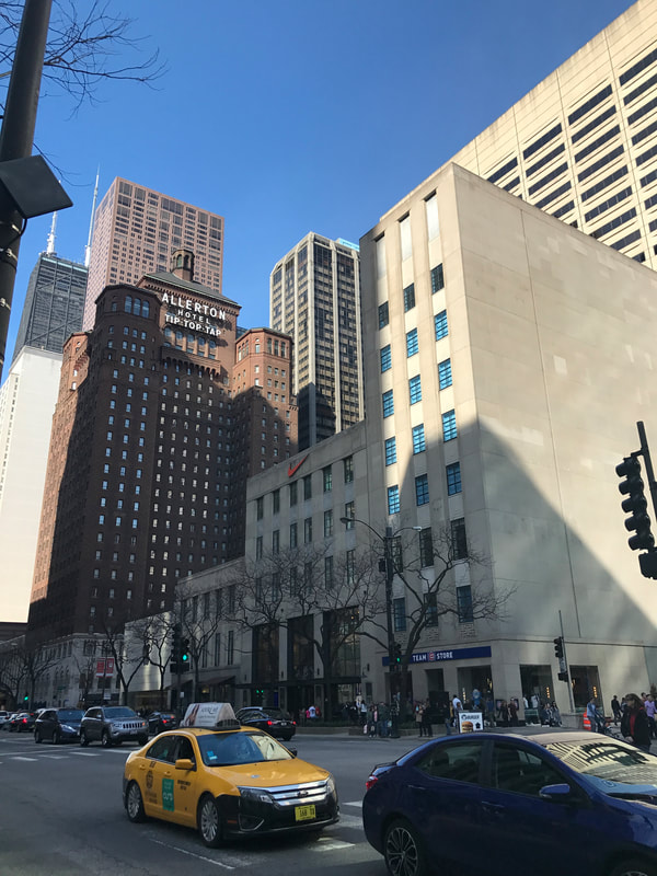
Allerton Hotel
The Warwick Allerton - Chicago (formerly Allerton Hotel and Warwick Allerton Hotel Chicago and Allerton Crowne Plaza Hotel) is a 25-story 360 ft (110 m) hotel skyscraper on the Magnificent Mile in the Near North Sidecommunity area of Chicago, Illinois. It was the first building in the city to feature pronounced setbacks and towers resulting from the 1923 zoning law. The building was designated a Chicago Landmark on May 29, 1998. When the Allerton Hotel first opened, it had fourteen floors of small apartment-style rooms for men and six similar floors for women, with a total of 1,000 rooms. The hotel also boasted social events, gold, sports leagues, a library, solarium, and an in-house magazine. In the 1940s and 1950s, the hotel housed a swanky lounge on its top floor, called the "Tip Top Tap". By 1963, the room was home to a new restaurant, the Cloud Room, when Don McNeill moved his broadcast of Don McNeill's Breakfast Club to the location. |
|
|
|
Art Institute of Chicago
In 1866, a group of 35 artists founded the Chicago Academy of Designin a studio on Dearborn Street, with the intent to run a free school with its own art gallery. Classes started in 1868, meeting every day at a cost of $10 per month. The Academy's success enabled it to build a new home for the school, a five-story stone building on 66 West Adams Street, which opened on November 22, 1870. When the Great Chicago Fire destroyed the building in 1871 the Academy was thrown into debt. Members tried to rescue the ailing institution by making deals with local businessmen, before some finally abandoned it in 1879 to found a new organization, named the Chicago Academy of Fine Arts. When the Chicago Academy of Design went bankrupt the same year, the new Chicago Academy of Fine Arts bought its assets at auction. In 1882, the Chicago Academy of Fine Arts changed its name to the current Art Institute of Chicago. The Art Institute of Chicago, founded in 1879 and located in Chicago’s Grant Park, is one of the oldest and largest art museums in the United States. Its permanent collection of nearly 300,000 works of art is augmented by more than 30 special exhibitions mounted yearly that illuminate aspects of the collection and present cutting-edge curatorial and scientific research. As a research institution, the Art Institute also has a conservation and conservation science department, five conservation laboratories, and one of the largest art history and architecture libraries in the country. |
|
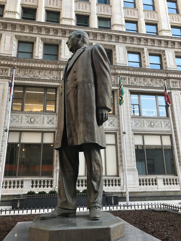
Benito Juarez Statue
Benito Juárez (1806 – 1872) was the first and only indigenous President of Mexico. Known as the builder of modern Mexico, he was committed to restoring the rights of his nation’s indigenous populations. A Zapotec Indian and national icon, Juárez has been called ‘the Lincoln of Mexico’ because, like Lincoln, Juárez supported the rights and ideals of all men. When Juárez was forced to flee Mexico City in 1858, Lincoln sent him a message of hope ‘for the liberty of your government and its people.’ The Benito Juárez statue stands in a plaza that honors the Latin American cultures represented in Chicago. Today there are towns, schools and roadways throughout the world named in honor of Juárez. |
|
|
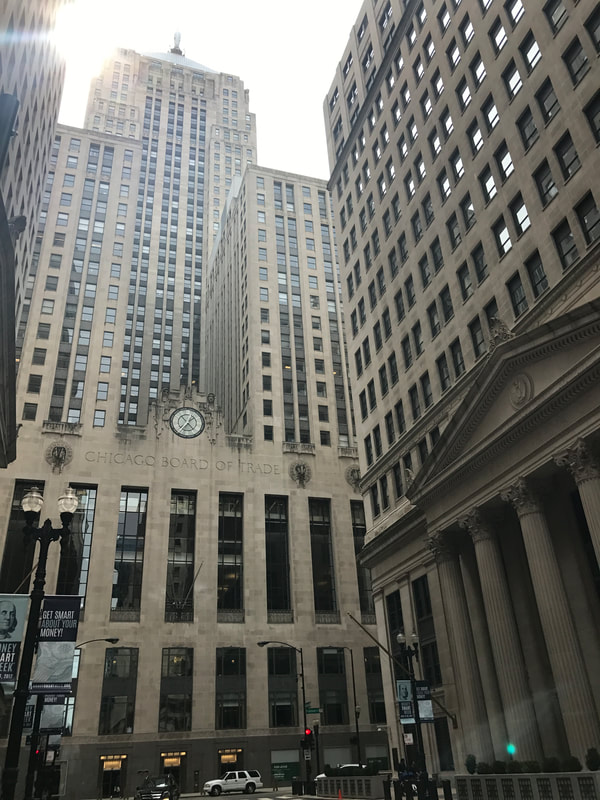
Chicago Board of Trade
The concerns of U.S. merchants to ensure that there were buyers and sellers for commoditieshave resulted in forward contracts to sell and buy commodities. Still, credit risk remained a serious problem. The CBOT took shape to provide a centralized location, where buyers and sellers can meet to negotiate and formalize forward contracts.Since 1930, the Chicago Board of Trade has been operating out of 141 West Jackson Boulevard, Chicago, in a building designed by architects Holabird & Root that is 605 feet (184 m) tall, the tallest in Chicago until the Richard J. Daley Center superseded it in 1965. This Art Deco building incorporates sculptural work by Alvin Meyer and is capped by a 31-foot (9.5 m) tall statue of the Roman goddess Ceres in reference to the exchange's heritage as a commodity market.Ceres is often claimed to be faceless because its sculptor, John Storrs, believed that the forty-five story building would be sufficiently taller than any other nearby structure and as a result that no one would be able to see the sculpture's face anyway. However, this popular rumor was disproved, with the sculptor intending to give the statue an ethereal and god-like look by being faceless |
|
Chicago Jail (MCC Chicago)
MCC Chicago was designed by architect Harry Weese. Construction began in 1971 and the facility opened in 1975. The building is a right triangle shape, extrudes 28 stories, and has a rooftop exercise yard. The irregularly-spaced windows on each wall are reminiscent of old computer punchcards. Several features make MCC Chicago's design unique from other federal prison facilities. Weese designed each cell with a floor-to-ceiling slit window, 7 feet long by 5 inches wide, narrow enough not to require bars, and beveled out to allow natural light to pass inside. The cells were originally designed to feel as comfortable as possible, based on sailboat cabins, with built-in hardwood beds and desks. Most of these features have since been removed. |
|
|
|
Cloud Gate
Cloud Gate is a public sculpture by Indian-born British artist Sir Anish Kapoor, that is the centerpiece of AT&T Plaza at Millennium Park. Constructed between 2004 and 2006, the sculpture is nicknamed The Bean because of its shape. Made up of 168 stainless steel plates welded together, its highly polished exterior has no visible seams. It measures 33 by 66 by 42 feet (10 by 20 by 13 m), and weighs 110 short tons (100 t; 98 long tons). Kapoor's design was inspired by liquid mercury and the sculpture's surface reflects and distorts the city's skyline. Visitors are able to walk around and under Cloud Gate's 12-foot (3.7 m) high arch. On the underside is the "omphalos" (Greek for "navel"), a concave chamber that warps and multiplies reflections. The sculpture builds upon many of Kapoor's artistic themes, and it is popular with tourists as a photo-taking opportunity for its unique reflective properties. Cloud Gate was formally dedicated on May 15, 2006, and has since gained considerable popularity, both domestically and internationally. |
|
Field Museum
The Field Museum of Natural History (FMNH), also known as The Field Museum, is a natural history museum in Chicago, and is one of the largest such museums in the world. The museum maintains its status as a premier natural-history museum through the size and quality of its educational and scientific programs, as well as due to its extensive scientific-specimen and artifact collections. The diverse, high-quality permanent exhibitions, which attract up to two million visitors annually, range from the earliest fossils to past and current cultures from around the world to interactive programming demonstrating today's urgent conservation needs. The museum is named in honor of its first major benefactor, the department-store magnate Marshall Field. The museum and its collections originated from the 1893 World’s Columbian Exposition and the artifacts displayed at the fair. |
|
|
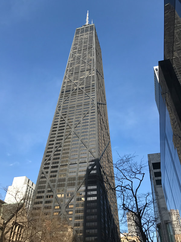
John Hancock Building
The John Hancock Center, is a 100-story, 1,128-foot skyscraper located in Chicago, Illinois. It was constructed under the supervision of Skidmore, Owings and Merrill, with chief designer Bruce Graham and structural engineer Fazlur Khan. When the building topped out on May 6, 1968, it was the second-tallest building in the world and the tallest outside New York City. It is currently the fourth-tallest building in Chicago and the ninth-tallest in the United States. When measured to the top of its antenna masts, it stands at 1,500 feet (457 m). The building is home to several offices and restaurants, as well as about 700 condominiumsThe building was named for John Hancock Mutual Life Insurance Company, developer and original tenant of the building. In 2018, John Hancock Insurance requested that its name be removed and the owner is seeking another naming rights deal. |
|
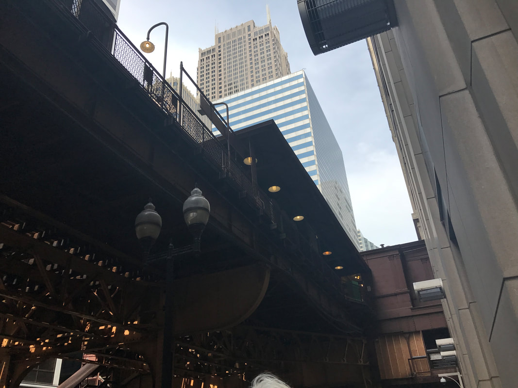
"L" Train
The Chicago "L" (short for "elevated”) is the rapid transit system serving the city of Chicago and some of its surrounding suburbs in the U.S. state of Illinois. Operated by the Chicago Transit Authority (CTA), it is the fourth-largest rapid transit system in the United States in terms of total route length, at 102.8 miles (165.4 km) long as of 2014, and the second-busiest rail mass transit system in the United States, after the New York City Subway. The oldest sections of the Chicago "L" started operations in 1892, making it the second-oldest rapid transit system in the Americas. The "L" has been credited with fostering the growth of Chicago's dense city core that is one of the city's distinguishing features. |
|

|
Magnificent Mile
The Magnificent Mile, sometimes referred to as The Mag Mile, is an upscale section of Chicago’s Michigan Avenue, running from the Chicago River to Oak Street in the Near North Side. The Magnificent Mile serves as the main thoroughfare between Chicago's Loop business district and its Gold Coast. Real estate developer Arthur Rubloff of Rubloff Company gave the district its nickname in the 1940s. Currently Chicago's largest shopping district, various mid-range and high-end shops line this section of the street; approximately 3,100,000 square feet (290,000 m2) are occupied by retail, restaurants, museums and hotels. |
|
Marquette Building
The building was named after Father Jacques Marquette, the first European settler in Chicago, who explored the Chicago region in 1674 and wintered in the area for the 1674-5 winter season. In the 1930s, the building was the downtown headquarters for over 30 railroad companies. Around 1950, the terra-cotta cornice was removed from the Marquette Building when an additional story was added. The building has been in continuous use as an office building since its construction. |
|
|
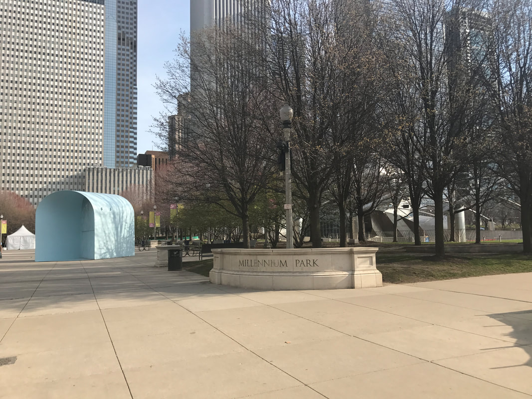
Millennium Park
Millennium Park is a public park operated by the Chicago Department of Cultural Affairs and managed by MB Real Estate. The park was originally intended to celebrate the third millennium and is a prominent civic center near the city's Lake Michigan shoreline. Planning of the park began in October 1997. Construction began in October 1998, and Millennium Park was opened in a ceremony on July 16, 2004, four years behind schedule. |
|
Navy Pier
Navy Pier opened to the public on July 15, 1916. Originally known as the "Municipal Pier", the pier was built by Charles Sumner Frost, a nationally known architect, with a design based on the Plan of Chicago (1909) by Daniel Burnham and Edward H. Bennett.Its original purpose was to serve as a dock for freights, passenger traffic, and indoor and outdoor recreation; events like expositions and pageants were held there. In the summer of 1918, the pier was also used as a jail for draft dodgers. In 1927, the pier was renamed Navy Pier to honor the naval veterans who served in World War I. In 1941, during World War II, the pier became a training center for the U.S. Navy; about 10,000 people worked, trained and lived there. In 1976, the East End buildings were renovated and for a brief period the pier was alive again, home to summer events like ChicagoFest.But maintenance was not done and the pier went into decline. Starting in 2014, the redevelopment plan called The Centennial Vision was implemented. The purpose of this plan is to fulfill the mission to keep Navy Pier as a world-class public space and to renovate the pier so it will have more evening and year-round entertainment and more compelling landscape and design features.The Centennial Vision was completed in summer 2016. |
|
|
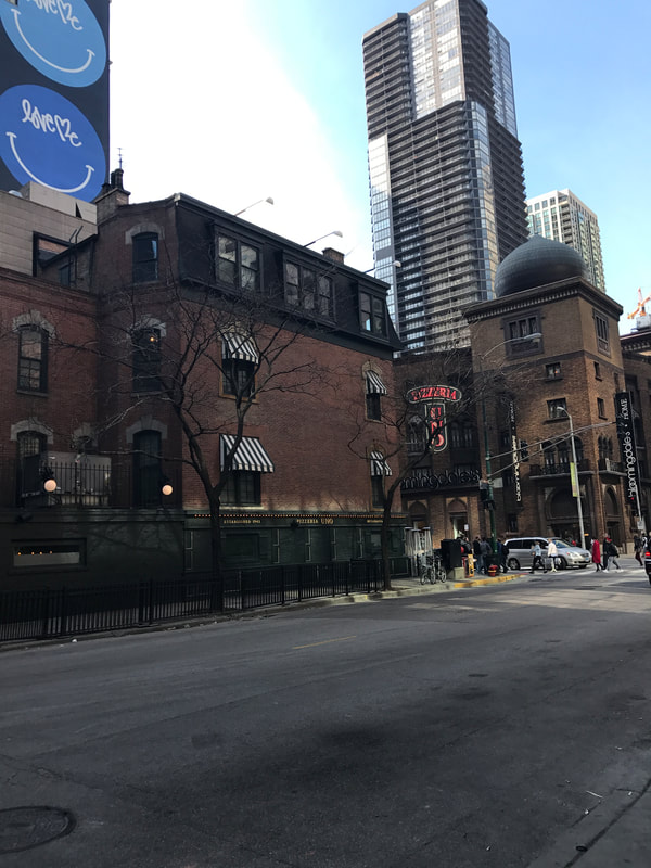
Pizzeria Uno
Ike Sewell changed things back in 1943 when he created Deep Dish Pizza. Some folks call it Chicago deep dish pizza. Ike figured that if you combined some of Italy's old, authentic recipes with impressive quantities of the finest meats, spices, vegetables and cheeses, pizza would become a hearty meal. So he opened Pizzeria Uno as a fine restaurant specializing in his new Chicago Deep Dish Pizza. |
|
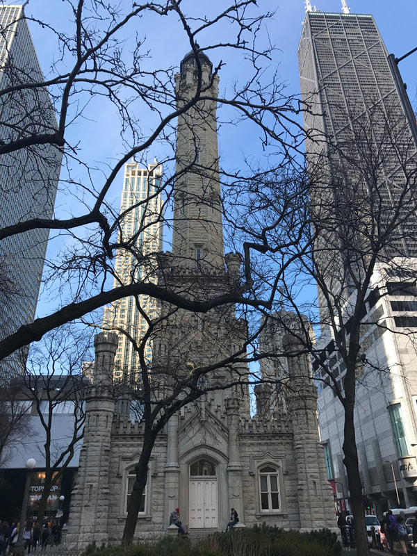
Water Tower
The tower, built in 1869 by architect William W. Boyington from yellowing Lemont limestone, is 182.5 feet (55 m) tall. Inside was a 138-foot (42 m) high standpipe to hold water. In addition to being used for firefighting, the pressure in the pipe could be regulated to control water surges in the area. Together with the adjacent Chicago Avenue Pumping Station, it drew clean water from water cribs in Lake Michigan. The tower gained prominence after the Great Chicago Fire of 1871. While some incorrectly believe that the tower was the only building to survive the fire, a few other buildings in the burned district survived along with the tower. The tower was the only public building in the burned zone to survive, and is one of just a few of the surviving structures still standing. In the years since the fire, the tower has become a symbol of old Chicago and of the city's recovery from the fire. In 1918, when Pine Street was widened, the plans were altered in order to give the Water Tower a featured location. |
|
|
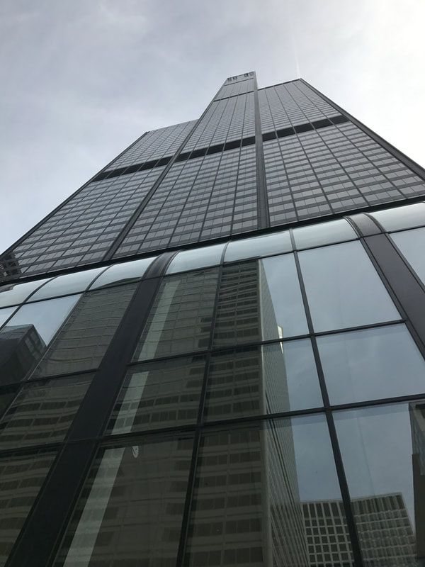
Willis Tower
The Willis Tower (also Sears Tower) is a 110-story 1,450-foot (442.1 m) skyscraper in Chicago, Illinois. At completion in 1973, it surpassed the World Trade Center in New York to become the tallest building in the world, a title it held for nearly 25 years. The Tower is considered a seminal achievement for architect Eazlur Bahman Khan. It is currently the second-tallest building in the United States and the Western hemisphere – and the 16th-tallest in the world. The structure was renamed in 2009 by the Willis Group as a term of its lease. |
|
Willis Tower Skydeck
The Willis Tower observation deck, called the Skydeck, opened on June 22, 1974. Located on the 103rd floor at an elevation of 1,353 feet (412.4 m), it is the highest observation deck in the United States and one of Chicago's most famous tourist attractions. Tourists can experience how the building sways in wind and see far over the plains of Illinois and across Lake Michigan to Indiana, Michigan, and Wisconsin in clear conditions. Elevators reach the top in about 60 seconds, allowing occupants to feel the change in pressure as they ascend. The Skydeck competes with the John Hancock Center’s observation floor a mile and a half away but reaching 323 feet (98.5 m) lower. In January 2009, a major renovation of the Skydeck was begun, including the installation of retractable glass balconies which extend approximately 4 feet (1.2 m) from the facade of the 103rd floor, overlooking South Wacker Drive. The all-glass boxes, informally dubbed "The Ledge", allow visitors to see the street below. The boxes, which can accommodate 5 short tons (4.5 metric tons), opened to the public on July 2, 2009. |
|
|
Wrigley Building
When ground was broken for the Wrigley Building in 1920, there were no major office buildings north of the Chicago River. The land was selected by chewing gum magnate William Wrigley Jr. for the headquarters of his company. The 425-foot (130 m) south tower was completed in April 1921 and the north tower in May 1924. Walkways between the towers were added at the ground level and the third floor. In 1931, another walkway was added at the fourteenth floor to connect to offices of a bank in accordance with a Chicago statute concerning bank branch offices. The two towers, not including the levels below Michigan Avenue, have a combined area of 453,433 square feet (42,125.3 m2). The two towers are of differing heights, with the south tower rising to 30 stories and the north tower to 21 stories. On the south tower is a clock with faces pointing in all directions. Each face is 19 feet 7 inches (5.97 m) in diameter. The building is clad in glazed terra-cotta, which provides its gleaming white façade. On occasion, the entire building is hand washed to preserve the terra cotta. The Wrigley Building was Chicago's first air-conditioned office building. |
Collinsville
Collinsville is the self-proclaimed "Horseradish Capital of the World", and sponsors an annual Horseradish Festival. The area is saidto produce 85% of the world's horseradish, of such high quality that Germany and China (key users of the herb) import it for gourmet use.
The Cahokia Mounds State Historic Site located within the city limits of Collinsville. The largest Pre-Columbian settlement north of Mexico, it was developed by the Mississippian culture. At its peak about 1200 CE, Cahokia had a population of 20,000-30,000, more than any city in the present-day United States until after 1800. It includes Monks Mound, the largest prehistoric earthwork in the Americas, and more than 70 surviving smaller mounds.
During the French colonial era of its Illinois Country, a group of French Catholic monks had a settlement on Monks Mound, after whom it was later named. They cultivated agriculture on the terraces of the mound. They traded with bands of the historic Illini, who had migrated into the area after the peak of the Mississippian culture.
Collinsville was originally settled by the Cook family and by a group of German-American settlers who arrived by Conestoga wagon in 1812 from Pennsylvania. They founded Holy Cross Lutheran Church. They also had a hardware store, though they were mainly farmers. Within five or six years, a number of other settlers arrived and began to organize the legal work required to form a town on the site.
During World War I, a Collinsville mob, composed mostly of local coal miners, lynched a German immigrant, the only such wartime murder in the country. On April 5, 1918, the mob numbering up to 300 men took Robert Prager from his home and paraded him through the streets barefoot and wrapped in an American flag, forcing him to sing patriotic songs. Collinsville police interceded and took Prager into protective custody. The mob was later mistakenly allowed to search city hall, and two men found Prager hiding in the basement. They took Prager outside and the mob marched him to the outskirts of town, along the St. Louis Road, where they lynched him. His final request was to be buried in the American flag. Eleven men stood trial for the murder, but all were acquitted on June 1, 1918.
|
|
Cahokia Mounds State Historic Site
The Cahokia Mounds State Historic Site is the site of a pre-Columbian Native American city (which existed circa 1050–1350 CE) directly across the Mississippi River modern St. Louis, Missouri. The park covers 2,200 acres (890 ha), or about 3.5 square miles (9 km2), and contains about 80 mounds, but the ancient city was much larger. At its apex around 1100 CE, Cahokia covered about 6 square miles (16 km2) and included about 120 manmade earthen mounds in a wide range of sizes, shapes, and functions.Cahokia was the largest and most influential urban settlement of the Mississippian culture, which developed advanced societies across much of what is now the central and southeastern United States, beginning more than 1,000 years before European contact. Today, Cahokia Mounds is considered the largest and most complex archaeological site north of the great pre-Columbian cities in Mexico. |
