|
I had it all planned out. My flight left at noon, so I was going to set my alarm for 8 a.m., but really get up at 9 a.m., which would give me an hour to drop off my car at the rental place and then get to the airport 2 hours early. And then my plans turned to dust. I snoozed my alarm and actually woke up at 8:30, to find out that my flight didn’t leave at noon like I had planned, it actually left at 11. I panicked and started throwing stuff in my suitcase so I could run out the door. I then go to the rental car place, which was not actually a rental place. At this point I’m panicking because I don’t remember how to get there because Kyle was driving. As I’m panicking I drive into the parking lot and I see a sign on the door saying that they have moved locations and it gave the new address. I put it in my phone and take off to the new location. In the process, I jumped a curve and heard a horrible scraping noise. I’m start cussing, but I have no time to look at the damage, so I keep going. I get to the new place and order my Uber. Then I get out to assess the damage. I look at the back of the car and I see this crack that runs from the bumper to the back door. At this point, I can’t do anything, so I get my stuff out and drop the keys in the drop box. Then I’m just waiting for the Uber driver. As I’m waiting, I look at the crack again. I actually touch it this time, and it is not a crack. It was oil or paint or something, and it rubbed off. Hallelujah!
By the time the Uber driver got to me, I had less than 2 hours until my flight. And it was a 45 minute drive to the airport. The uber driver was really nice and we talked about random stuff on the way to the airport. I finally get to the airport and I have 1 hour to check my bag and get through Security. And of course, the line to check in a bag is wraps around to almost the other side of the building. So I get in line and I’m checking my watch every 1 minute because I don’t want to miss my flight. I’m debating not checking my bag, but I brought a pocket knife for when I went hiking. So I would have to dump the knife and some liquids. I figure I would wait in line for 30 minutes and I wasn’t at the front by then I would dump everything. Luckily, after 30 minutes I was able to check in my bag and then I ran for Security. The Security line wasn’t that bad, and I went through it pretty quickly. I arrived at my gate with 2 minutes to spare until boarding time. The gate attendant made an announcement that we would be boarding in 10 minutes, so I ran to get some breakfast before the flight. But I made it back to Dallas!
0 Comments
My original plan was to start the Brighton Lakes Trail bright and early at 8 a.m. Well, that didn’t happen. I actually didn’t end up leaving the hotel until 8, so I didn’t get to the trail until about 9 a.m. I didn’t know where the trail was, but it was at the end of the scenic drive that I took on Wednesday with Jacob and Kyle. So I got to drive the windy trail again. I had to pull to the side a couple of times because a line was forming behind me. I’m not used to driving on roads that windy, so I ended up going very slow. But I eventually made it to the ski resort on top. I couldn’t find the path so I started walking one direction, but luckily AllTrails saved me again and I quickly found out I was heading in the opposite direction. So I turned around and found the path, which was located behind the resort. There were all sorts of tents set up in front of it, but I just bypassed them.
 I stayed on the ridge about 30 minutes, just enjoying the views and then I headed back down. I walked towards Lake Catherine, but then turned around and went back up. I saw the lake, so I didn’t see the point of walking around it.
By this time, I really had to go to the bathroom. And it wasn’t like I could walk off the trail and go behind a tree. Nope, the trees weren’t that tall, and you could see clearly down the mountain. So whoever was above me on the trail would be able to see me. I would have to go pretty far off the trail as well, because there was a lot of traffic on that trail. So I held it as I walked the 3 miles back towards the ski lodge. I did have a mishap. Remember the stream I had to hike up? Well, it is a lot harder to hike down the stream, as I found out when I wiped out. Luckily I didn’t fall too far, and I just scraped my knee and hands up a little. There were big boulders on the side of the stream, so I sat there for a while before continuing downward. I barely drew blood on one finger, and it was clotted by the time I made it out of the stream. Luckily, I had a first aid kit in my backpack with disinfecting wipes. So I cleaned the area and continued on. It didn’t even need a Band-Aid. I was actually supposed to take a different path that would loop around to my car, but this path was about a mile longer than the way I had gone up. I didn’t know if I would be able to make it to the end, so I kept to the path I came up on. I had to hurry down, because I could feel my poop coming down with gravity. So I was not able to take as many breaks on the way down, but I made it to the ski lodge and the bathroom just in time. The tents I had passed on my way up the mountain were still there and they were selling different types of outdoors equipment. I saw snowboards, and different hiking equipment. I guess that is one good way to target outdoorsy people. By this time I was all hot and sweaty, so I got in my car and drove back to my hotel. I need a shower bad! But I had to be quick because I had a full day planned ahead of me.
Then I went into the village. It is a recreation village. People donate houses from the 1700s or 1800s, that are somehow still standing. They move the houses into the village. Then historians research the house and recreate the inside so it looks like it did when the house was originally built. They try to keep the original purpose of the house in mind when they are doing their recreations. Not all of the houses are originals, some they recreated based on the original.
 They also have a school house in the village, and they give lessons which I thought was cool. If I had more time, I would have stayed to listen to one. I wondered around some more, walking into random houses.
I tried to get some food, because by this time I was starving. I thought I would be able to stop in somewhere on the way and get some fast food for lunch, but I didn’t see anything until it was too late. They had hot dogs, but they were taking forever, so I left and got some ice cream.  Another house I stopped in was the drug store. They had a lot of medicinal looking vials. There were people in there ahead of me talking to guy behind the counter, so I just took some pictures and left.
 I also stopped in the telegraph office, which was operating in 1861. The guy in there was pretty cute. By this time, I wasn’t as awkward about asking questions. So I asked why there was a lot of civil war gear in the telegraph office. He told me that the telegraph office was also the recruiting office during the civil war. I asked for which side, and he said both. He told me how it made sense since the military communication at the time was through telegraph, so it centralized things.  I continued on to the saddlery. I knew I had to ask a question, so I asked why there was fur and a buffalo head in there. The guy looked at me and said he didn’t really know. He was funny, and he told me how he told 2 kids that the buffalo was just sticking his head through the wall, but the rest of him was on the other side. The 2 kids then ran out of there to find the other end of the buffalo. He was funny, but I continued on making my way towards the exit. By this time it was 4:45, and they closed at 5.
 There was also a bronze statue of Brigham Young, who was Utah’s first territorial governor. I tried to go in other rooms, like the House and Senate Chambers and the Supreme Court, but the doors were locked. They had a picture on the pamphlet, so I could see that. Also, there was a thin crack in the doors, so I put my eye up against and I could see part of the room  Walking around the Capitol Building didn’t take long, so I got in my car and drove down to Temple Square to do one of the free walking tours there. Downtown was really confusing, and I had trouble finding a place to park. But I eventually found one and hurried across the street to the Square to the meeting place of the flag pole. There were a lot of guide there holding signs. They offer the tour in multiple languages. Each of the tour guides also had badges with their names on them and a small flag with their country. I of course went to the English tour. We had 2 tour guides, one from the U.S. and the other from Mongolia. The one from Mongolia was a little hard to understand because of her accent, but they were both nice. We had people from all over the U.S. Several of them had come for the eclipse. Salt Lake City is supposed to get a view of the full eclipse, while Texas will only get a partial view. I was still really surprised that people actually travel for that.  Our first stop on the tour was the Tabernacle. It is a huge dome shape room that is their church. It was designed so someone could stand at the podium and everyone would be able to hear them without a microphone. They did a demonstration where they dropped different items like a coin or a pin, and I could hear it at the back of the church. After the demonstration, out guides told us a little bit of the history of the place. Brigham Young was one of the Mormon prophets, and he prayed to God about how to build the tabernacle, and he received a name: Henry Grow. Henry Grow had never built a house, he was known for building bridges. So that is what he did, he built the bridges, and lashed them together and that is why the tabernacle has the dome shape.  Our next stop was a statue of some people pulling a hand cart. Our guides explained how the Mormon religion was founded. It was started by Joseph Smith in the 1820s in New York. Smith found an ancient book written in another language, and the Book of Mormon is the translated version of this book. This book was written about 900 years before the Bible and continues after the Bible. So Mormon read multiple books, the Book of Mormon and the Bible, which they use as a reference. Mormonism wasn’t accepted by the Christian society where the Mormon’s settled and a mob killed Joseph Smith and his brother (and successor) Hyrum Smith. After they were killed, Brigham Young gathered the remaining Mormons and they journeyed to unknown territories and eventually settled in Salt Lake City and founded the state of Utah. Most of the Mormons were poor and could not afford horses, so they carried everything in handcarts. We also found out the structure of their religion. They are different because they believe the prophets still live among us. The leader of their church is considered to be a prophet, and when he dies the next highest ranking apostle will become the new prophet. My group was a talkative one, and they asked a lot of questions. Like how are Mongolian guide converted. So she walked us through the process. They asked about every day life. Someone asked about the clothes (both guides were wearing dresses/skirts), and our guides told us that dresses/skirts are not required. They only wear them because they are giving the tour in order to look more professional, but they can wear whatever they want. I expected someone to ask about multiple wives, but no one did and I didn’t want to be the one to raise the issue. Several of the people were very interested in the Mormon religion, so they might have some converts coming.
Our guides also told us that people can stand in for their relatives if they never had the chance to convert to Mormonism to ensure the family remains together. Our American guides stood in for her grandmother since her grandmother wasn’t a Mormon. They can also stand in for relatives at the marriage ceremony to ensure the family remains together. Our guide also told us that she had a non-Mormon friend that asked the Mormon community to stand in for his family in order ensure the family remains together in the after life. All in all, the tour was interesting and I’m glad I learned more about the Mormon culture. After the tour was over, I walked through the exhibit. It was interesting. I then walked to the Temple. Usually, at churches the doors are open or you see people entering or leaving. That wasn’t happening, so I didn’t know if we were allowed to go inside. Especially since they consider the Temple sacred, I didn’t want to go inside and start taking pictures. So I hung around outside and rested for a while, took some pictures of the Temple, and then walked back to my car. My last stop for the day was to be Ensign Peak. I drove there, but I couldn’t find a place to park. Then I was looking up at this hill, and I just couldn’t do it. I was so exhausted from all of the walking that I had done over the day and my feet hurt. So I decided to pass. I knew a little about the history. A couple of days after the Mormons settled in Salt Lake City, Brigham Young and the church leaders walked to the top of the hill and could see all of the Salt Lake City below them. At that point, I was satisfied with just seeing the hill. So I drove back to my hotel in Sandy, UT. Outside the hotel is a sandwich shop, so I stopped in and got a sandwich and a salad. Finally I got to eat and it was delicious. Then I went to my room, took a shower, then laid down and refused to move. I looked at my fitbit, and I had almost 29,000 steps. That is how many steps I average in 2 weeks, let alone 1 day. I watched some TV, then set my alarm for 8 a.m. tomorrow.
We were at the client until about 1 p.m., and then we left. Kyle to catch his flight and me to start my Utah adventure. Kyle drove (even though we wasn’t supposed to) me to Enterprise. I typed the address into my phone, but we ended up in a random place where there was no Enterprise. Luckily, Kyle was able to search for Enterprise on his phone and drive me there. He dropped me off, and I went in to get my rental. The guy that helped me was super nice. He did a walk around with me around the car, and he was much more thorough than I would have been. Finally, we finished and I was able to continue on my journey. I went to my hotel (Home2Suites because Hilton was booked) and checked in. Then I quickly changed before heading out to Mount Timpanogos. I bought a ticket a couple of weeks ago to see the Mount Timpanogos cave. I got the National Parks app, which included national monuments. This place is one of the monuments, so I decided to visit it.  I got there a couple of minutes after 3:30, which was my assigned start time. I’m glad I bought my ticket beforehand, because there was a sign that they were sold out of tickets. The lady gave me the spiel of making sure I had enough water, a jacket, and that my shoes and clothes had never been in a cave before. Apparently there is a disease going through the bat populations called White Nose Syndrome which is killing bat around North America. I forgot to bring a jacket, but they said it would only be 45 degrees in the cave, so I decided to chance it I started hiking the 1.5 miles up to the cave. They give you an hour and a half to make it to the top. I though that was more than enough time before I got started. I mean surely I could walk faster than a mile an hour. It took me every second of that hour and a half to make it to the tope. At first it wasn’t too bad and I was able to maintain a steady pace, but the longer I walked the harder it got
Also along the route were benches to give weary hikers a rest. I’m still mad at one group of people because of the bench. I was struggling up the mountain and I could see the bench ahead. I was focused on it, and struggling to put one foot in front of the other to make it to that bench. When out of nowhere a group of people run down (yes, that’s right DOWN) the mountain and fill up the whole bench. I couldn’t believe it! I was so pissed at them! And I’m still pissed at them. So I stood there a while catching my breath and then continued my journey up. As I got closer and closer to the top I met several people heading down. They were very encouraging and let me know that I was almost there. I was really excited when I could see the end in sight. I had finally made it! And at exactly 5 p.m. too. There were a lot of people waiting for the tour to start. So I walked towards the edge of the path and took some pictures. I then went and took a picture of the sign to the caves. A family came up behind me to take a photo in front of the sign, so I offered to take their photo. I was hoping someone would offer to take my photo afterwards. But another family lined up behind that one, so I offered to take theirs with the same expectation. Nope, another family was behind that one and then we had to run in the caves. I’m lucky I made it in the caves. I made it to the caves on time for my tour group, but apparently other people didn’t. The tour guide is only supposed to take 16 people in at a time and there were 21 of us. I could see that she wanted to leave me behind, but the next tour didn’t go until 5:45, and it was 5 then. And after all, I had made it to the caves at my designated time, so she let me in. There were a lot of families there, which I was surprised about. That was a hard hike! Especially for younger kids.
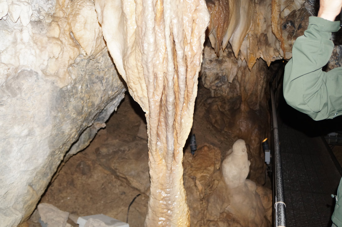
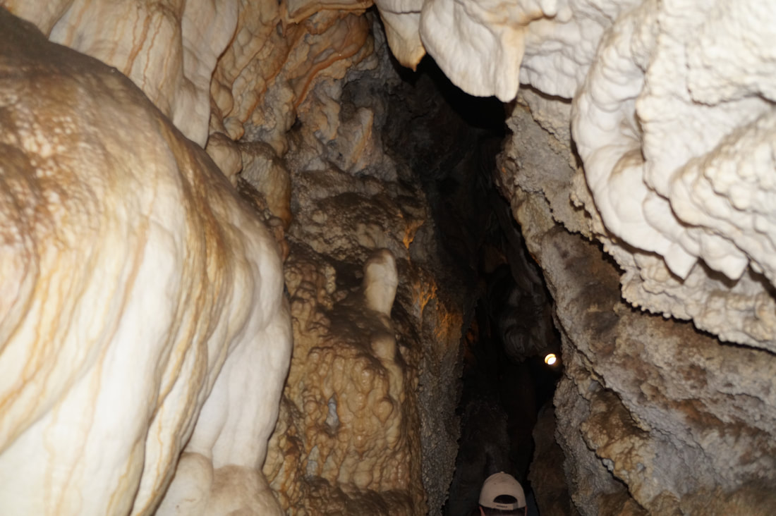
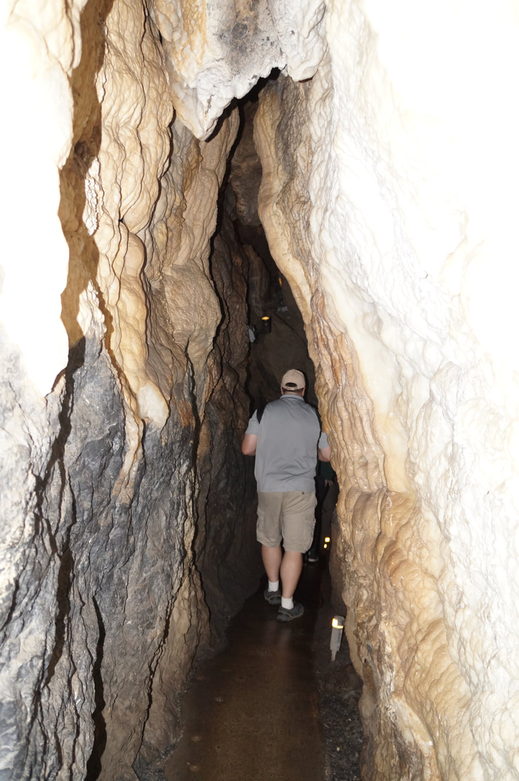
 Next we went through a door and into one of the manmade tunnels. Our guide had a flashlight and she pointed out little baby stalactites that were barely a bump in the ceiling. The manmade tunnel was formed 80 years ago, so that shows you how long it takes those things to form. She also told us a little about stalactites. They are formed by groundwater dripping from the ceiling. Each drop have minerals in them, and when they drop to the ground, the mineral stays and eventually hardens into the stalactites. This process takes hundreds if not millions of years.
 The caves have been completely submerged in water at times, which you can see by the muddy looking walls. The walls and ground are also wet, because ground water is still seeping into the cave. Which made some areas really slippery.
 In one of the cave we got to see what they call the “heart” of the caves. It is a huge structure that apparently weighs over 1 ton. It was down in the cave and it looked huge! At one point our guide turned off all of the lights to show us how caves are completely dark. At home, even with the lights off there is still light somewhere so you can make out shapes in front of you as your eyes adjust to the light. Not so in the cave. When she turned out the light I tried waving my hand in front of my face and I couldn’t see anything! Now the shape or the movement of something happening inches from my eyes.
I had rationed my water on the way up, which not everyone was smart enough to do. I heard others talking that they had used up all of their water on the way up the mountain. No lie, I was tempted but I knew I had to be conservative. I had 2 bottles of water, so I rationed it for 1 on the way up and 1 on the way down. Which was another reason I wanted to be last, I didn’t want the big groups of families seeing me chugging water and then want some. I would then have to share with everyone and I would no longer have water. According to my AllTrails app I hiked 3.3 miles. At the tope I was at about 7,500 ft above see level. I started at about 5,500 ft, and I walked up about 1,800 ft. That 1,800 ft was why it took my so long. But I have to keep practicing if I want to do the Inca Trail. Afterwards I really wanted some Dairy Queen. There is actually Dairy Queens in Utah (unlike Oklahoma), so I decided to drive to one. Sadly, it was in a mall. At least I think it was, but I didn’t actually go in the mall. I found a Chilis, so I sat at the bar and ordered a skillet chocolate chip cookie, which I devoured. Then I returned to my hotel to relax and plan my adventure for tomorrow.
I’m in Utah working on a benefit plan client this week. Which is cool because my work is paying for me to travel. I’m working with Kyle and Jacob this week. We left the client about 5:30 p.m., and went back to our hotels to change before heading to Big Cottonwood. Kyle had looked up online best scenic drives around Salt Lake City and Big Cottonwood popped up. Sadly, I had to drive because Kyle’s driver’s license had expired the week before so he wasn’t allowed to drive the rental car. Utah is really strict about that. When we would eat dinner he couldn’t use his driver’s license as an ID because it was expired, but luckily he had his passport to use as an ID. Kyle had asked the client about Big Cottonwood, and they said it is a beautiful drive and only 12 minutes away. I don’t know about it being 12 minutes away (unless you speed), but it was certainly beautiful. There was a long line to get into the area. A car had flipped over completely on its side. How does that even happen? It didn’t look like anyone was hurt, and there were no ambulances. Police were directing traffic around accident, so we didn’t have to wait too long. We followed Big Cottonwood up to Brighton Ski Resort, which was at the top of the path. I didn’t get to enjoy the scenery very much because I was driving and I had to focus on the road. The path was very windy. I had to pull to the side several times because I was going so slow and the drivers behind me were getting annoyed. But from what I saw, the mountains were beautiful. There were also little streams of water running through the area, and I wish we could have parked the car and gotten out to enjoy them.
I have recently decided that I want to hike the Inca Trail. It is one of the top 5 trails in the world. I know that I have to prepare in order to go, so I have taken up hiking in my free time. I got up early and went to Whataburger for breakfast, and then I drove to Cedar Hill State Park which is only 15-20 minutes from my house. When I got there I went into the main building to buy a Texas State Parks Pass. The pass costs $70 but it allows me to get into all Texas State Parks for free for the next year. The don't take American Express credit cards for payment, but luckily I brought another credit card with me.
After paying and getting my new pass, I drove down to the DOBRA Trail. Along the way, I pass some beautiful scenery. The park is right by Cedar Hill Lake and the from the road you could see a lot of the lake. They also have other things to do besides hiking, like camping, fishing, or just hanging out at the lake. They also have a marina, but it is currently closed for repairs. The trail I wanted to hike is located at the far side of the park. I took a picture of the map before I started on the trail, and then chose the path for hikers. The other path was for bikers, and they travel clockwise around the trail loop. Hikers walk counter-clockwise that way when bikers are coming we can see them and have time to get out of the way. The path is pretty narrow, so I don't know how the bikers ride it, but they do. The path is dirt and it was springy from the recent rain but not muddy. The trail is really pretty and quiet. There were places were you could hear cars passing by, but for most of the trail all you could hear was nature. The path starts out by following the lake, so the views were gorgeous. There are 3 parts to the DOBRA Trail. There is a small trail that is 3 miles, a medium trail that is 8 miles, and long trail that is 12 miles. The whole trail is a loop, so you have time to decide which trail you want to take. I hadn't decided by the time I came to the split off for the 8 mile trail and I was standing there deciding. I also wanted to take a picture of the decision point so I could post it on social media, when a woman came up behind me. She saw me standing off to the side and wanted to make sure I wasn't lost. I didn't want to admit that I was going to take a picture for social media, so I told her I was trying to decide if I was up for an 8 mile hike. She let me know that there is a maintenance trail that cuts through, and that hike around 5 miles. That sounded a lot better than 8 miles! She started giving me directions and I just looked at her blankly, because this is my first time on the trail I told her I took a picture of the map and showed it to her on my phone. She looked at it and said the white dotted line must be the maintenance trail. I thanked her and we both chose the path for the medium trail. She walked a lot faster than me, so she pulled ahead and I didn't see her again. Other than her and a guy walking his dog, I really didn't see anyone else hiking. A lot of bikers past me, but that was it. I think the trail will be a lot prettier in the spring when the flowers come out. I saw some flowers, but they were mostly dead from the heat. I did like that half of the trail is in the shade, especially since I didn't have any sunblock to put on. The trail is also very winedy, which adds to the number of steps I got. I usually fry in the sun, but I didn't get sunburned at all. Yeah! I stayed on the trail until I finally saw the maintenance road. I saw the road earlier, but I didn't know for sure if it was the maintenance trail, and I didn't want to start following a random trail and get lost. I went off on the maintenance trail. This trail is a lot wider than the other trails, which makes sense because they have to be able to drive to get to the far side of the park if someone gets injured. The downside to having the wide trail is that there was no longer any shade. So I hiked along there for a while, and then turned off where I thought the trail was. It took a while to get back to the main hiking trail, and I started to get worried that I took a wrong turn. Luckily I have the AllTrails app and started a recording at the beginning of the trail. This app is awesome! It shows me the trail, how far I've gone, where I am on the trail, and how far I had to go. With it, I was able to navigate back to the main trail and continue on my journey. As I got closer to where I parked, a lot of bikers started passing me. I kept having to jump out of the way so I wouldn't get hit. One guy came around a corner too fast and surprised me. He slammed on the break, hit a root wrong and crashed out. Luckily he wasn't hurt, and he got back on his bike and rode off. I heard the bike, but another bicyclist had just passed me so I thought it was his bike I was hearing. I continued on going, and I finally made it back to my starting point. According to the AllTrails app I hiked 5.2 miles. I had another app recording my hike as well, which is called Charity Miles. Basically, they have sponsors and for every mile that I hiked the sponsor donate money to the charity of my choice. I chose the National Parks Foundation. I figure since I am hiking in a park to get the mileage, the money should go to a foundation that supports parks. According to this app, I hiked 5.91 miles. So I hiked around 5.5 miles today. I did learn some valuable information: 1. Bring at least 2 water bottles. My water ran out when I still had a mile to go and I about died trying to get back to my car. Especially since by this point it was around noon. Luckily, I still had water in my car from Whataburger that was still cold, so I was able to rehydrate. 2. Bring a hat. I didn't get to enjoy a lot of the scenery because the sun was in my eyes a lot of the time. All in all, I really enjoyed my hike. I'll try it again next weekend, and work up to the 8 mile trail. Before I go to Peru for the Inca Trail, I need to be hiking the 12 mile trail. That is the current goal I'm working towards. |
Categories
All
Archives
June 2022
AuthorThese are details from my adventures around the world. |
| Cory's Travel Blog |
|
- Blog
- About
- Europe
- Africa
- Asia
-
The Americas
-
North America
>
- Mexico
-
United States
>
- Alabama
- California
- Colorado
- Connecticut
- Delaware
- Florida
- Georgia
- Hawaii
- Illinois
- Indiana
- Iowa
- Kansas
- Kentucky
- Louisiana
- Maine
- Maryland
- Massachusetts
- Mississippi
- Missouri
- Nebraska
- Nevada
- New Hampshire
- New Mexico
- North Carolina
- New Jersey
- Ohio
- Oklahoma
- Pennsylvania
- Rhode Island
- South Carolina
- Texas
- Virginia
- Washington D.C.
- South America >
- Central America >
-
North America
>
- Oceania
- Special Attractions


 RSS Feed
